Limerick, Louisville: Difference between revisions
m copyedit, already indirectly in category, refine cat, and AWB general fixes using AWB |
add "use mdy dates" template |
||
| (26 intermediate revisions by 18 users not shown) | |||
| Line 1: | Line 1: | ||
{{Use mdy dates|date=August 2023}} |
|||
{{Infobox NRHP |
{{Infobox NRHP |
||
| name = Limerick Historic District |
| name = Limerick Historic District |
||
| nrhp_type = hd |
| nrhp_type = hd |
||
| image = Limerick Historic District.jpg |
| image = Limerick Historic District.jpg |
||
| caption = Large mansion house built by "lace curtain" Irish in the 1890s |
| caption = Large mansion house built by "lace curtain" Irish in the 1890s |
||
| location= Between Breckinridge and Oak, 5th and 8th St., [[Louisville, Kentucky]] |
| location = Between Breckinridge and Oak, 5th and 8th St., [[Louisville, Kentucky]] |
||
| locmapin = Kentucky |
| locmapin = Kentucky#USA |
||
| built = 1860 |
| built = 1860 |
||
| architect |
| architect = |
||
| architecture = Queen Anne |
| architecture = Queen Anne, Romanesque, Victorian |
||
| added = |
| added = September 13, 1978 |
||
| increase = December 23, 1983 |
|||
| area = {{convert|47|acre}} |
| area = {{convert|47|acre}} |
||
| |
| refnum = 78001360 |
||
| increase_refnum = 83003715 |
|||
| refnum = 83003715<ref name="nris">{{NRISref|version=2010a}}</ref> |
|||
| nocat = yes |
|||
| ⚫ | |||
}} |
}} |
||
'''Limerick''' is a neighborhood one mile south of downtown [[Louisville, Kentucky]], USA. |
|||
| ⚫ | |||
==History== |
|||
| ⚫ | |||
| ⚫ | The neighborhood was developed in the 1860s as a place of residence for employees of the [[Louisville and Nashville Railroad]] freight yard. It was named because nearly all of the residents were from the [[Ireland|Irish]] county of [[Limerick]]. The St. Louis Bertrand [[Catholic Church]] was the centerpiece of the newly founded neighborhood. Limerick began the trend of working-class people living southwest of downtown, a trend which continues in the city to this day. |
||
| ⚫ | The [[working class]] Irish [[immigrant]]s lived in modest [[shotgun house]]s, with a moderate number of [[African American]]s living in the alleyways behind them, while upper income Irish, known as "lace curtain Irish", built mansion houses on St. Catherine Street. The Irish [[Catholicism|Catholic]] presence in Limerick was strong enough that from 1872 to 1918 an annual [[St Patrick's Day]] march went from the church to Broadway. But as many of the [[railroad]] jobs left the area, the Irish began to move to [[South Louisville]]. |
||
| ⚫ | |||
| ⚫ | On October 7, 1871, the [[ |
||
| ⚫ | The [[working class]] Irish [[immigrant]]s lived in modest [[shotgun house]]s, with a moderate number of [[African American]]s living in the alleyways behind them, while upper income Irish, known as "[[Lace curtain and shanty Irish|lace curtain Irish]]", built mansion houses on St. Catherine Street. The Irish [[Catholicism|Catholic]] presence in Limerick was strong enough that from 1872 to 1918 an annual [[St Patrick's Day]] march went from the church to Broadway. But as many of the [[railroad]] jobs left the area, the Irish began to move to [[South Louisville]]. |
||
| ⚫ | On October 7, 1871, the [[Louisville Steam Engine Co. 7]] was formed to provide fire protection to the "southern suburbs" of Louisville. Its firehouse at 821 S. 6th Street is the oldest continuously active firehouse in the U.S. On December 10, 2008, Louisville Mayor [[Jerry Abramson]] announced his intention to close the firehouse and disband the company on January 1, 2009.<ref>{{cite news |first=Jessie |last=Halladay |title=1871 firehouse to close doors |url=/proxy/http://www.courier-journal.com/article/20081211/NEWS01/812110441 |archive-url=/proxy/https://archive.today/20120730023601/http://www.courier-journal.com/article/20081211/NEWS01/812110441 |url-status=dead |archive-date=2012-07-30 |newspaper=[[The Courier-Journal]] |date=2008-12-11 |access-date=2008-12-30}}</ref> |
||
| ⚫ | |||
As the Irish left, the African Americans moved from the alleyways into the vacated shotgun houses. In 1873, [[Louisville Central Public School]], Kentucky's first state supported public school for African Americans was opened at 6th and Kentucky Streets. It would be later renamed Simmons College and finally Municipal College for Negros, a "colored" campus of the [[University of Louisville]]. The school is now in the process of reclaiming its former campus and is officially known as [[Simmons College of Kentucky]]. |
As the Irish left, the African Americans moved from the alleyways into the vacated shotgun houses. In 1873, [[Louisville Central Public School]], Kentucky's first state supported public school for African Americans was opened at 6th and Kentucky Streets. It would be later renamed Simmons College and finally Municipal College for Negros, a "colored" campus of the [[University of Louisville]]. The school is now in the process of reclaiming its former campus and is officially known as [[Simmons College of Kentucky]]. |
||
| Line 29: | Line 36: | ||
The news weekly ''[[Kentucky Irish American]]'' would be published from Limerick for nearly seventy years, starting in 1898. |
The news weekly ''[[Kentucky Irish American]]'' would be published from Limerick for nearly seventy years, starting in 1898. |
||
==Historic preservation== |
|||
Today, Limerick is a [[historic preservation]] district. It is bounded by Breckinridge Street to the north, 5th street to the east, Oak Street to the south, and the [[CSX Transportation|CSX]] railroad tracks to the west. South of Oak street, the eastern boundary is 7th street until it crosses the railroad tracks. |
Today, Limerick is a [[historic preservation]] district. It is bounded by Breckinridge Street to the north, 5th street to the east, Oak Street to the south, and the [[CSX Transportation|CSX]] railroad tracks to the west. South of Oak street, the eastern boundary is 7th street until it crosses the railroad tracks. |
||
| Line 42: | Line 50: | ||
==External links== |
==External links== |
||
{{commons category|Limerick Historic District}} |
|||
*[http://www.ecentral.com/louisvillemaps/limerick.html Street map of Limerick] |
*[https://web.archive.org/web/20100128234843/http://www.ecentral.com/louisvillemaps/limerick.html Street map of Limerick] |
||
*[http://digital.library.louisville.edu/cdm4/results.php?CISORESTMP=results.php&CISOVIEWTMP=item_viewer.php&CISOMODE=grid&CISOGRID=thumbnail,A,1;title,A,1;descri,200,0;none,200,0;none,A,0;20;title,none,none,none,none&CISOBIB=title,A,1,N;subjec,A,0,N;descri,200,0,N;none,A,0,N;none,A,0,N;20;title,none,none,none,none&CISOTHUMB=20%20(4x5);title,none,none,none,none&CISOTITLE=20;title,none,none,none,none&CISOHIERA=20;subjec,title,none,none,none&CISOSUPPRESS=0&CISOTYPE=link&CISOOP1=exact&CISOFIELD1=title&CISOBOX1=&CISOOP2=exact&CISOFIELD2=coveraa&CISOBOX2=Limerick+%28Louisville%2C+Ky.%29&CISOOP3=exact&CISOFIELD3=descri&CISOBOX3=&CISOOP4=exact&CISOFIELD4=CISOSEARCHALL&CISOBOX4=&c=exact&CISOROOT=all Images of Limerick (Louisville, Ky.) in the University of Louisville Libraries Digital Collections] |
*[http://digital.library.louisville.edu/cdm4/results.php?CISORESTMP=results.php&CISOVIEWTMP=item_viewer.php&CISOMODE=grid&CISOGRID=thumbnail,A,1;title,A,1;descri,200,0;none,200,0;none,A,0;20;title,none,none,none,none&CISOBIB=title,A,1,N;subjec,A,0,N;descri,200,0,N;none,A,0,N;none,A,0,N;20;title,none,none,none,none&CISOTHUMB=20%20(4x5);title,none,none,none,none&CISOTITLE=20;title,none,none,none,none&CISOHIERA=20;subjec,title,none,none,none&CISOSUPPRESS=0&CISOTYPE=link&CISOOP1=exact&CISOFIELD1=title&CISOBOX1=&CISOOP2=exact&CISOFIELD2=coveraa&CISOBOX2=Limerick+%28Louisville%2C+Ky.%29&CISOOP3=exact&CISOFIELD3=descri&CISOBOX3=&CISOOP4=exact&CISOFIELD4=CISOSEARCHALL&CISOBOX4=&c=exact&CISOROOT=all Images of Limerick (Louisville, Ky.) in the University of Louisville Libraries Digital Collections] |
||
*[http://orig.courier-journal.com/reweb/community/placetime/city-limerick.html "Limerick: Generosity Was Cornerstone Upon Which Irish and Blacks Built Their Neighborhood"] — Article by Pat O'Connor of ''[[The Courier-Journal]]'' |
*[http://orig.courier-journal.com/reweb/community/placetime/city-limerick.html "Limerick: Generosity Was Cornerstone Upon Which Irish and Blacks Built Their Neighborhood"] — Article by Pat O'Connor of ''[[The Courier-Journal]]'' |
||
| Line 56: | Line 65: | ||
| South = [[Old Louisville]] |
| South = [[Old Louisville]] |
||
| Southeast = |
| Southeast = |
||
}} |
|||
{{Louisville neighborhoods}} |
|||
{{Louisville}} |
{{Louisville}} |
||
{{National Register of Historic Places}} |
{{National Register of Historic Places}} |
||
[[Category:Irish-American culture in Louisville, Kentucky]] |
[[Category:Irish-American culture in Louisville, Kentucky]] |
||
[[Category:Irish-American neighborhoods]] |
|||
[[Category:Neighborhoods in Louisville, Kentucky]] |
[[Category:Neighborhoods in Louisville, Kentucky]] |
||
[[Category:Local preservation districts in Louisville, Kentucky]] |
[[Category:Local preservation districts in Louisville, Kentucky]] |
||
| Line 66: | Line 77: | ||
[[Category:African-American history in Louisville, Kentucky]] |
[[Category:African-American history in Louisville, Kentucky]] |
||
[[Category:Historic districts on the National Register of Historic Places in Kentucky]] |
[[Category:Historic districts on the National Register of Historic Places in Kentucky]] |
||
[[Category:Populated places established in the 1860s]] |
|||
[[Category:1860s establishments in Kentucky]] |
|||
[[Category:Working-class culture in the United States]] |
|||
Latest revision as of 22:22, 7 August 2023
Limerick Historic District | |
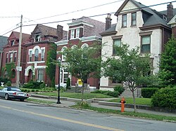
 Large mansion house built by "lace curtain" Irish in the 1890s | |
| Location | Between Breckinridge and Oak, 5th and 8th St., Louisville, Kentucky |
|---|---|
| Coordinates | 38°14′24″N 85°45′46″W / 38.23986548°N 85.76286077°W |
| Area | 47 acres (19 ha) |
| Built | 1860 |
| Architectural style | Queen Anne, Romanesque, Victorian |
| NRHP reference No. | 78001360 (original) 83003715 (increase) |
| Significant dates | |
| Added to NRHP | September 13, 1978 |
| Boundary increase | December 23, 1983 |
Limerick is a neighborhood one mile south of downtown Louisville, Kentucky, USA.
History
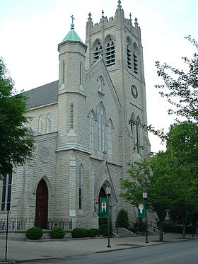
[edit]The neighborhood was developed in the 1860s as a place of residence for employees of the Louisville and Nashville Railroad freight yard. It was named because nearly all of the residents were from the Irish county of Limerick. The St. Louis Bertrand Catholic Church was the centerpiece of the newly founded neighborhood. Limerick began the trend of working-class people living southwest of downtown, a trend which continues in the city to this day.
The working class Irish immigrants lived in modest shotgun houses, with a moderate number of African Americans living in the alleyways behind them, while upper income Irish, known as "lace curtain Irish", built mansion houses on St. Catherine Street. The Irish Catholic presence in Limerick was strong enough that from 1872 to 1918 an annual St Patrick's Day march went from the church to Broadway. But as many of the railroad jobs left the area, the Irish began to move to South Louisville.
On October 7, 1871, the Louisville Steam Engine Co. 7 was formed to provide fire protection to the "southern suburbs" of Louisville. Its firehouse at 821 S. 6th Street is the oldest continuously active firehouse in the U.S. On December 10, 2008, Louisville Mayor Jerry Abramson announced his intention to close the firehouse and disband the company on January 1, 2009.[1]

As the Irish left, the African Americans moved from the alleyways into the vacated shotgun houses. In 1873, Louisville Central Public School, Kentucky's first state supported public school for African Americans was opened at 6th and Kentucky Streets. It would be later renamed Simmons College and finally Municipal College for Negros, a "colored" campus of the University of Louisville. The school is now in the process of reclaiming its former campus and is officially known as Simmons College of Kentucky.
Beginning around 1874 Limerick was the site of two successive baseball fields, both named Eclipse Park and located at 7th and Kentucky streets (across the street from each other). They were the home of Louisville's major league team, the Louisville Colonels (originally the Louisville Eclipse) from 1882 until the team folded in 1899. It was here that Hall of Famer Honus Wagner made his major league debut on July 19, 1897.
The news weekly Kentucky Irish American would be published from Limerick for nearly seventy years, starting in 1898.
Historic preservation
[edit]Today, Limerick is a historic preservation district. It is bounded by Breckinridge Street to the north, 5th street to the east, Oak Street to the south, and the CSX railroad tracks to the west. South of Oak street, the eastern boundary is 7th street until it crosses the railroad tracks.
Demographics
[edit]As of 2000, the population of Limerick was 1,448, of which 56.5% are black, 37.7% are white, 3.8% are listed as other, and 2% are Hispanic. College graduates are 17.3% of the population, people without a high school degree are 21.2%. Males outnumber females 63.7% to 46.3%.
See also
[edit]References
[edit]- ^ Halladay, Jessie (December 11, 2008). "1871 firehouse to close doors". The Courier-Journal. Archived from the original on July 30, 2012. Retrieved December 30, 2008.
External links
[edit]- Irish-American culture in Louisville, Kentucky
- Irish-American neighborhoods
- Neighborhoods in Louisville, Kentucky
- Local preservation districts in Louisville, Kentucky
- National Register of Historic Places in Louisville, Kentucky
- African-American history in Louisville, Kentucky
- Historic districts on the National Register of Historic Places in Kentucky
- Populated places established in the 1860s
- 1860s establishments in Kentucky
- Working-class culture in the United States


