South Gloucestershire
| South Gloucestershire | |
|---|---|
 | |
| Status | Unitary Authority, District |
| Region | South West England |
| Zerem. Grafschaft | Gloucestershire |
| Trad. Grafschaft | Gloucestershire |
| Verwaltungssitz | Yate |
| Fl�che | 496,94 km� |
| Einwohner | 282.644 |
| Stand | 30. Juni 2018[1] |
| ISO-3166-2 | GB-SGC |
| ONS-Code | 00HD |
| GSS-Code | E06000025 |
| Website | www.southglos.gov.uk |
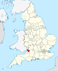
South Gloucestershire ist eine selbst�ndige Verwaltungseinheit (Unitary Authority) im S�dwesten Englands.
Geschichte
[Bearbeiten | Quelltext bearbeiten]Die Unitary Authority entstand 1996, als die Grafschaft County of Avon aufgel�st wurde und deren Distrikte Kingswood und Northavon zu South Gloucestershire zusammengefasst wurden. South Gloucestershire grenzt an Bristol, Bath and North East Somerset, Gloucestershire und Wiltshire und geh�rt zur Region South West England. Der Verwaltungssitz befindet sich in Yate.
Bevor das Gebiet von South Gloucestershire 1974 in die neu gebildete Grafschaft County of Avon eingegliedert wurde, geh�rte es zur Grafschaft Gloucestershire. Heute ist South Gloucestershire verwaltungstechnisch unabh�ngig und geh�rt nur noch zu zeremoniellen Anl�ssen zu Gloucestershire.
Gr��ere St�dte in South Gloucestershire
[Bearbeiten | Quelltext bearbeiten]Weitere St�dte und D�rfer
[Bearbeiten | Quelltext bearbeiten]- Abson, Acton Turville, Almondsbury, Alveston, Aust, Awkley
- Badminton, Bagstone, Bitton, Bridgeyate
- Cadbury Heath, Catbrain, Charfield, Chipping Sodbury, Churchend, Coalpit Heath, Codrington, Cold Ashton, Cowhill, Cromhall
- Dodington, Downend, Doynton, Duckhole, Dyrham
- Easter Compton, Elberton, Engine Common
- Falfield, Frampton Cotterel
- Gaunt's Earthcott
- Hawkesbury, Hawkesbury Upton, Hill, Hillesley, Hallen, Hambrook, Hanham, Harry Stoke, Hinton, Horton
- Ingst, Iron Acton, Itchington
- Latteridge, Little Badminton, Little Sodbury, Little Stoke, Littleton-upon-Severn, Longwell Green
- Marshfield, Milbury Heath, Upper and Lower Morton
- Nibley, Northwick
- Oldbury Naite, Oldbury-upon-Severn, Old Down, Oldland, Old Sodbury, Olveston, Over
- Patchway, Pilning, Pucklechurch
- Rangeworthy, Redwick, Rockhampton, Rudgeway
- Severn Beach, Shepperdine, Siston, Soundwell, Stoke Gifford
- Tockington, Tormarton, Tortworth, Tresham, Tytherington
- Upton Cheyney
- Wapley, Warmley, West Littleton, Westerleigh, Whitfield, Wick, Wickwar, Winterbourne
Weblinks
[Bearbeiten | Quelltext bearbeiten]Einzelnachweise
[Bearbeiten | Quelltext bearbeiten]Koordinaten: 51° 29′ N, 2° 23′ W
Grafschaften Englands mit zweistufiger Verwaltung (Non-Metropolitan Counties)
Cambridgeshire |
Derbyshire |
Devon |
East Sussex |
Essex |
Gloucestershire |
Hampshire |
Hertfordshire |
Kent |
Lancashire |
Leicestershire |
Lincolnshire |
Norfolk |
Nottinghamshire |
Oxfordshire |
Staffordshire |
Suffolk |
Surrey |
Warwickshire |
West Sussex |
Worcestershire
Unitary Authorities
mit County Status
Bath and North East Somerset |
Bedford |
Blackburn with Darwen |
Blackpool |
Bournemouth, Christchurch and Poole |
Brighton and Hove |
Bristol |
Buckinghamshire |
Central Bedfordshire |
Cheshire East |
Cheshire West and Chester |
Cornwall |
Cumberland |
County Durham |
Darlington |
Derby |
Dorset |
East Riding of Yorkshire |
Halton |
Hartlepool |
Herefordshire |
Isle of Wight |
Kingston upon Hull |
Leicester |
Luton |
Medway |
Middlesbrough |
Milton Keynes |
North East Lincolnshire |
North Lincolnshire |
North Northamptonshire |
North Somerset |
North Yorkshire |
Northumberland |
Nottingham |
Peterborough |
Plymouth |
Portsmouth |
Redcar and Cleveland |
Rutland |
Shropshire |
Somerset |
Southampton |
Southend-on-Sea |
South Gloucestershire |
Stockton-on-Tees |
Stoke-on-Trent |
Swindon |
Telford and Wrekin |
Thurrock |
Torbay |
Warrington |
West Northamptonshire |
Westmorland and Furness |
Wiltshire |
York
ohne County Status
Bracknell Forest |
Reading |
Slough |
West Berkshire |
Windsor and Maidenhead |
Wokingham
sui generis, ohne County Status
Isles of Scilly