
Khachaghbyur: Difference between revisions
Content deleted Content added
Armenian orthog & alt name |
No edit summary |
||
| (45 intermediate revisions by 36 users not shown) | |||
| Line 1: | Line 1: | ||
{{distinguish|Karchaghbyur}} |
|||
{{ |
{{coord|40|10|20|N|45|41|19|E|display=title}} |
||
{{Infobox |
{{Infobox settlement |
||
|official_name =Khachaghbyur |
| official_name = Khachaghbyur |
||
|native_name = |
|||
| |
| native_name = Խաչաղբյուր |
||
| |
| image_skyline = Murad Khach.jpg |
||
| image_caption = A view of Khachaghbyur from Murad Khach |
|||
| ⚫ | |||
| |
| pushpin_map = Armenia#Gegharkunik |
||
| ⚫ | |||
| ⚫ | |||
| ⚫ | |||
| ⚫ | |||
| |
| subdivision_name = [[Armenia]] |
||
| ⚫ | |||
| ⚫ | |||
| ⚫ | |||
|established_title = |
|||
| subdivision_type2 = [[Municipalities of Armenia|Municipality]] |
|||
|established_date = |
|||
| subdivision_name2 = [[Vardenis Municipality|Vardenis]] |
|||
|area_total_km2 = |
|||
| population_footnotes = <ref name="2011census">{{Cite web|url=/proxy/https://armstat.am/file/article/1._bajin_1_182-311.pdf|title=The results of the 2011 Population Census of Armenia|author=[[Statistical Committee of Armenia]]}}</ref> |
|||
|area_footnotes = |
|||
|population_as_of = [[ |
| population_as_of = [[Census in Armenia|2011]] |
||
|population_total = |
| population_total = 1,064 |
||
| timezone = [[Armenia Time|AMT]] |
|||
|population_density_km2 = |
|||
| ⚫ | |||
|timezone = |
|||
| coordinates = {{coord|40|10|20|N|45|41|19|E|region:AM|display=inline}} |
|||
|utc_offset = +4 |
|||
| ⚫ | |||
|timezone_DST = |
|||
|utc_offset_DST = +5 |
|||
|latd=40 |latm=10 |lats=20 |latNS=N |
|||
|longd=45|longm=41 |longs=19 |longEW=E |
|||
|elevation_m = |
|||
|area_code = |
|||
| ⚫ | |||
}} |
}} |
||
'''Khachaghbyur''' ({{lang-hy|Խաչաղբյուր}}, also [[Romanize]]d as '''Khach’aghbyur''', '''Khachagbur''', and '''Khachagbyur'''; formerly, '''Chakhyrlu''', '''Chakhrlu''', and '''Sovetakert''') is a town in the [[Gegharkunik|Gegharkunik Province]] of [[Armenia]]. |
|||
'''Khachaghbyur''' ({{lang-hy|Խաչաղբյուր}}) is a village in the [[Vardenis Municipality]] of the [[Gegharkunik Province]] of [[Armenia]]. The village is located immediately to the south of the [[Lusakunk]] village and to the west of [[Vardenis]]. |
|||
== Etymology == |
|||
The village was previously known as ''Chakhyrlu'', ''Chakhrlu'', ''Chakhirlu'', ''Sovietakert'' and ''Sovetakert''. |
|||
== History == |
|||
Near the village is a ruined Iron Age fort, ''Murad Khach'', as well as a 13th-century church.<ref name="Kiesling">{{cite book|last1=Kiesling| first1=Brady| first2=Raffi| last2= Kojian| year=2005 |title=Rediscovering Armenia: Guide| edition= 2nd| publisher=Matit Graphic Design Studio| location=Yerevan| page=81| isbn=99941-0-121-8}}</ref> |
|||
== Gallery == |
|||
<gallery mode="packed" heights="240"> |
|||
Murad Khach2.jpg|Khachkar on Murad Khach |
|||
Murad Khach1.jpg|Murad Khach |
|||
</gallery> |
|||
== References == |
== References == |
||
{{reflist}} |
|||
| ⚫ | |||
*[http://world-gazetteer.com/wg.php?x=&men=gcis&lng=en&des=wg&geo=-17&srt=npan&col=abcdefghinoq&msz=1500&pt=c&va=x World Gazeteer: Armenia] – World-Gazetteer.com |
|||
== External links == |
|||
{{Commons}} |
|||
* {{ArmenianCensus|146}} |
|||
* {{RediscoveringArmenia|47}} |
|||
{{Gegharkunik|state=expanded}} |
|||
{{portal bar|Geography}} |
|||
[[Category: |
[[Category:Populated places in Gegharkunik Province]] |
||
[[Category:Gegharkunik]] |
|||
{{ |
{{gegharkunik-geo-stub}} |
||
Latest revision as of 23:01, 18 February 2023
40°10′20″N 45°41′19″E / 40.17222°N 45.68861°E
Khachaghbyur
Խաչաղբյուր | |
|---|---|
 A view of Khachaghbyur from Murad Khach | |
 Khachaghbyur  Khachaghbyur | |
| Coordinates: 40°10′20″N 45°41′19″E / 40.17222°N 45.68861°E | |
| Country | Armenia |
| Province | Gegharkunik |
| Municipality | Vardenis |
| Population | |
| • Total | 1,064 |
| Time zone | UTC+4 (AMT) |
| Khachaghbyur at GEOnet Names Server | |
Khachaghbyur (Armenian: Խաչաղբյուր) is a village in the Vardenis Municipality of the Gegharkunik Province of Armenia. The village is located immediately to the south of the Lusakunk village and to the west of Vardenis.
Etymology
[edit]The village was previously known as Chakhyrlu, Chakhrlu, Chakhirlu, Sovietakert and Sovetakert.
History
[edit]Near the village is a ruined Iron Age fort, Murad Khach, as well as a 13th-century church.[2]
Gallery
[edit]-
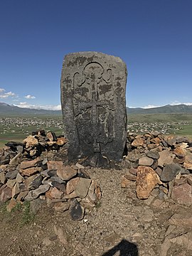 Khachkar on Murad Khach
 -
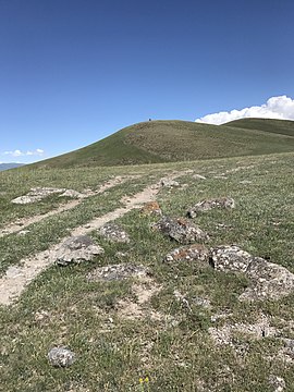 Murad Khach


References
[edit]- ^ Statistical Committee of Armenia. "The results of the 2011 Population Census of Armenia" (PDF).
- ^ Kiesling, Brady; Kojian, Raffi (2005). Rediscovering Armenia: Guide (2nd ed.). Yerevan: Matit Graphic Design Studio. p. 81. ISBN 99941-0-121-8.
External links
[edit]Wikimedia Commons has media related to Khachaghbyur.
- Report of the results of the 2001 Armenian Census, Statistical Committee of Armenia
- Kiesling, Brady (June 2000). Rediscovering Armenia: An Archaeological/Touristic Gazetteer and Map Set for the Historical Monuments of Armenia (PDF). Archived (PDF) from the original on 6 November 2021.

This article about a location in Gegharkunik Province, Armenia is a stub. You can help Wikipedia by expanding it. |