
Portal:Indiana
The Indiana Portal
Various indigenous peoples inhabited what would become Indiana for thousands of years, some of whom the U.S. government expelled between 1800 and 1836. Indiana received its name because the state was largely possessed by native tribes even after it was granted statehood. Since then, settlement patterns in Indiana have reflected regional cultural segmentation present in the Eastern United States; the state's northernmost tier was settled primarily by people from New England and New York, Central Indiana by migrants from the Mid-Atlantic states and adjacent Ohio, and Southern Indiana by settlers from the Upland South, particularly Kentucky and Tennessee.
Indiana has a diverse economy with a gross state product of $352.62 billion in 2021. It has several metropolitan areas with populations greater than 100,000 and a number of smaller cities and towns. Indiana is home to professional sports teams, including the NFL's Indianapolis Colts and the NBA's Indiana Pacers. The state also hosts several notable competitive events, such as the Indianapolis 500, held at Indianapolis Motor Speedway. (Full article...)
Selected article -
.svg)
The Indiana Territory, officially the Territory of Indiana, was created by an organic act that President John Adams signed into law on May 7, 1800, to form an organized incorporated territory of the United States that existed from July 4, 1800, to December 11, 1816, when the remaining southeastern portion of the territory was admitted to the Union as the state of Indiana. The territory originally contained approximately 259,824 square miles (672,940 km2) of land, but its size was decreased when it was subdivided to create the Michigan Territory (1805) and the Illinois Territory (1809). The Indiana Territory was the first new territory created from lands of the Northwest Territory, which had been organized under the terms of the Northwest Ordinance of 1787. The territorial capital was the settlement around the old French fort of Vincennes on the Wabash River, until transferred to Corydon near the Ohio River in 1813.
William Henry Harrison, the territory's first governor, oversaw treaty negotiations with the Native inhabitants that ceded tribal lands to the U.S. government, opening large parts of the territory to further settlement. In 1809 the U.S. Congress established a bicameral legislative body for the territory that included a popularly-elected House of Representatives and a Legislative Council. In addition, the territorial government began planning for a basic transportation network and education system, but efforts to attain statehood for the territory were delayed due to war. At the outbreak of Tecumseh's War, when the territory was on the front line of battle, Harrison led a military force in the opening hostilities at the Battle of Tippecanoe (1811) and in the subsequent invasion of Canada during the War of 1812. After Harrison resigned as the territorial governor, Thomas Posey was appointed to the vacant governorship, but the opposition party, led by Congressman Jonathan Jennings, dominated territorial affairs in its final years and began pressing for statehood. (Full article...)
Selected image -
 |
Did you know -
- ... that William N. Salin was twice decorated with the Sagamore of the Wabash?
- ... that the Leedy Manufacturing Company of Indianapolis, Indiana, was at one point the largest manufacturer of drums in the world?
- ... that LGBT rights activist Kit Malone helped create the first transgender organized marching group in the Indianapolis Pride Parade's history?
- ... that the veto of an Indiana law that bans transgender girls from participating in school sports was overridden by the state legislature?
- ... that the first studio of Indiana high school radio station WETL was a cedar closet that had once stored furs?
- ... that in 1981 Indiana State University–Evansville received a donation valued at nearly $300,000 in the form of campus radio station WSWI?
Related portals
Selected geographic article -

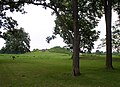
Carmel (/ˈkɑːrməl/) is a suburban city in Hamilton County, Indiana, United States, immediately north of Indianapolis. With a population of 99,757 as of the 2020 census, the city spans 49 square miles (130 km2) across Clay Township and is bordered by the White River to the east and the Boone County line to the west. Carmel was home to one of the first electronic automated traffic signals in the country, and has now constructed 141 roundabouts between 1988 and 2022. (Full article...)
Selected biography -

George Rogers Clark (November 19, 1752 – February 13, 1818) was an American military officer and surveyor from Virginia who became the highest-ranking Patriot military officer on the northwestern frontier during the Revolutionary War. He served as leader of the Virginia militia in Kentucky (then part of Virginia) throughout much of the war. He is best known for his captures of Kaskaskia in 1778 and Vincennes in 1779 during the Illinois campaign, which greatly weakened British influence in the Northwest Territory (then part of the British Province of Quebec) and earned Clark the nickname of "Conqueror of the Old Northwest". The British ceded the entire Northwest Territory to the United States in the 1783 Treaty of Paris.
Clark's major military achievements occurred before his thirtieth birthday. Afterward, he led militia forces in the opening engagements of the Northwest Indian War, but was accused of being drunk on duty. He was disgraced and forced to resign, despite his demand for a formal investigation into the accusations. Clark left Kentucky to live in the Indiana Territory but was never fully reimbursed by the Virginian government for his wartime expenditures. During the final decades of his life, he worked to evade creditors and suffered living in increasing poverty and obscurity. He was involved in two failed attempts to open the Spanish-controlled Mississippi River to American traffic. Following a stroke and the amputation of his right leg, he became disabled. Clark was aided in his final years by family members, including his younger brother William, one of the leaders of the Lewis and Clark Expedition. He died of a stroke on February 13, 1818. (Full article...)
Selected quote
General images
-
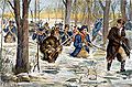 Clark's march to Vincennes, by F. C. Yohn (from History of Indiana)
 -
 Madame C. J. Walker, Indianapolis entrepreneur and philanthropist (from History of Indiana)
 -
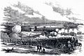 80th Indiana Infantry Regiment and the 19th Indiana Light Artillery defending against the Confederates at the Battle of Perryville by H. Mosler (from History of Indiana)
 -
-
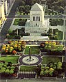
 The fifth Indiana Statehouse in Indianapolis built in 1888 on the site of the third statehouse (from History of Indiana)
 -
-
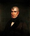 William Henry Harrison, the 1st Governor of Indiana Territory from 1801 to 1812, and the 9th President of the United States (from History of Indiana)
 -
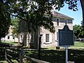
 The Constitution Elm in Corydon (from History of Indiana)
 -
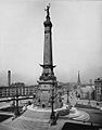 The Circle in Indianapolis, circa 1898 (from History of Indiana)
 -
 Native Americans guide French explorers through Indiana as depicted by Maurice Thompson in Stories of Indiana. (from History of Indiana)
 -
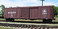 A restored Monon boxcar at the Linden Railroad Museum in Linden, Indiana (from History of Indiana)
 -
 View of Mound A at Angel Mounds (from History of Indiana)
 -
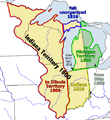 Map of the Indiana Territory (from History of Indiana)
 -
 A labor leader rallies striking steelworkers in Gary, Indiana (from History of Indiana)
 -
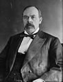 Oliver Hazard Perry Morton, governor 1861 to 1867 (from History of Indiana)
 -

-
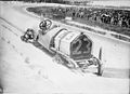 Driver Mel Marquette's wrecked McFarlan racing car at the 1912 Indianapolis 500 (from History of Indiana)


.jpg)

Topics

- Economy: AM General - ATA Airlines - Casinos - Cummins - Delta - ITT - JayC - Lilly - Limestone - Manufacturing - NiSource - Shoe Carnival - Simon Property Group - Soybeans - Studebaker - Vectren - WellPoint
- Geography: Caves - Lakes - Rivers - State forests - Watersheds
| Executive |  | |
|---|---|---|
| Legislature | ||
| Judiciary | ||
| Departments | ||
| Local government | ||
| Law | ||
Sports teams based in Indiana | |||||||||
|---|---|---|---|---|---|---|---|---|---|
| Baseball |  | ||||||||
| Basketball | |||||||||
| Football | |||||||||
| Hockey | |||||||||
| Motorsport | |||||||||
| Roller derby | |||||||||
| Soccer | |||||||||
| Ultimate | |||||||||
| Volleyball | |||||||||
| College athletics |
| ||||||||


Categories

Attractions


 |

Recognized content
| This is a list of recognized content, updated weekly by JL-Bot (talk · contribs) (typically on Saturdays). There is no need to edit the list yourself. If an article is missing from the list, make sure it is tagged (e.g. {{WikiProject Indiana}}) or categorized correctly and wait for the next update. See WP:RECOG for configuration options. |
Good articles
- 1963 Indiana State Fairgrounds Coliseum gas explosion
- 2006 Brickyard 400
- 2011 South Bend mayoral election
- 2015 South Bend mayoral election
- 2019 South Bend mayoral election
- 2021 NCAA Division I men's basketball championship game
- Max Bielfeldt
- The Fault in Our Stars (film)
- Hurley Goodall
- R. Ames Montgomery
- Proposed South Shore Line station in South Bend
- Richmond, Indiana, facility fire
- WCAE
Featured pictures
-
 Kenje Ogata 1943
 -
 Kurt Vonnegut by Bernard Gotfryd (1965)
 -
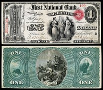 US-NBN-IL-Lebanon-2057-Orig-1-400-C

.jpg)

WikiProjects
State facts
Indiana | |
|---|---|
| Country | United States |
| Admitted to the Union | December 11, 1816 (19th) |
| Capital | Indianapolis |
| Largest city | Indianapolis |
| Largest metro and urban areas | Indianapolis-Carmel MSA |
| Government | |
| • Governor | Eric Holcomb (R) (2017) |
| • Lieutenant Governor | Suzanne Crouch (R) (2017) |
| Legislature | Indiana General Assembly |
| • Upper house | Senate |
| • Lower house | House of Representatives |
| U.S. senators | Todd Young (R) Mike Braun (R) |
| Population | |
| • Total | 6,080,485 |
| • Density | 169.5/sq mi (65.46/km2) |
| Language | |
| • Official language | English |
| Latitude | 37° 46′ N to 41° 46′ N |
| Longitude | 84° 47′ W to 88° 6′ W |
.JPG)


Things you can do
 |
Here are some tasks awaiting attention:
|
Associated Wikimedia
The following Wikimedia Foundation sister projects provide more on this subject:
-
 Commons
Free media repository -
 Wikibooks
Free textbooks and manuals -
 Wikidata
Free knowledge base -
 Wikinews
Free-content news -
 Wikiquote
Collection of quotations -
 Wikisource
Free-content library -
 Wikiversity
Free learning tools -
 Wikivoyage
Free travel guide -
 Wiktionary
Dictionary and thesaurus


- ^ a b "Elevations and Distances in the United States". U.S Geological Survey. 29 April 2005. Retrieved 2006-11-06.
{{cite web}}: CS1 maint: year (link)